Category Archives: Utah

Photo: Canyonlands National Park

canyonlands-national-park

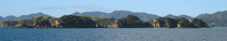
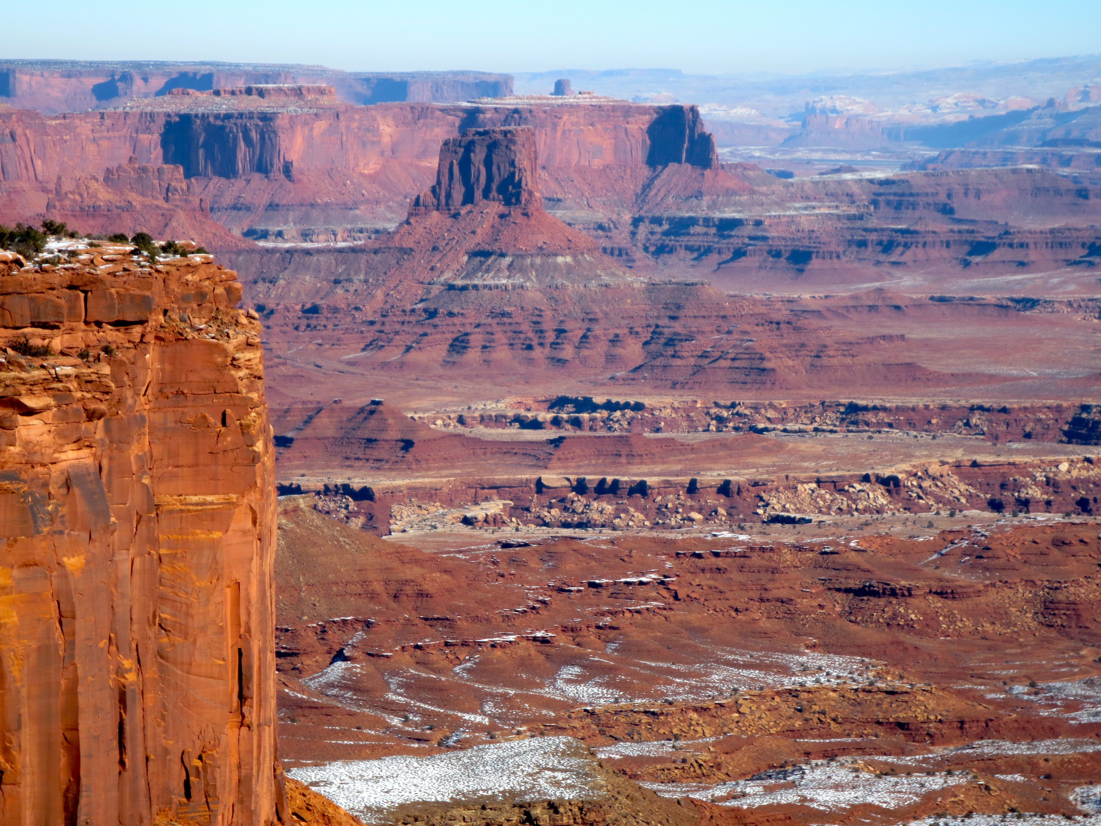
I think after this I am done posting a million billion scenery pictures from my time in Utah, but couldn’t resist one last one from Canyonlands National Park.  The park is where the Colorado River merges with the Green River, and used to be a site for cattle ranching and uranium mining until it became a national park in the 1960s.

This photo was taken from the Island in the Sky, which is a sizeable mesa 1,000 feet above the surrounding valley (sizeable here defined as it takes at least 15 minutes to drive across it) and with just a very narrow neck connecting it to the non-canyon surrounds barely large enough for a 2 lane highway.  You can’t see it in this picture but there’s a 4×4 dirt track around the bottom of the Island in the Sky that’s 100 miles long called White Rim Road that takes several days to complete.  Talk about an adventure!

Canyonlands was also interesting because not to sound like a broken record on this, but so few people go there the gate was closed and you had to go into the ranger station to pay the fee.  So when I did I asked the ranger there how many people visited every day which in national parks is measured by the door count (read: not entirely accurate especially in summer when you don’t have to stophere), and he said the previous day was about 200 people, but in the summer it’s more like 2,000 people.  This was still the tail end of “winter rush” though, as in a few days after new year’s, so for the rest of winter (ie around now as you read this) they’d be looking at maybe 30 visitors a day.

I asked at Arches too, which is more popular for several reasons, and they said the door count in “winter rush” is more like 300 (note, they keep someone at the gate here so you don’t have to go in) but in the summer it’s more like 3,000 people a day.  I guess my conclusion out of all of this was to not be timid when it comes to visiting national parks when out of season especially if you want some solace- the weather was fine so long as you had a jacket and normal cold weather gear, and if anything I think my pictures look better for all the snow!  Plus I’m not entirely certain why you’d want to come here in summer anyway when the temperatures soar over 100 degrees Fahrenheit… it doesn’t sound very comfortable for hiking.

Photo: Upheval Dome Meteor Crater

upheval-dome-meteor-crater

Most of Canyonlands National Park (an hour’s drive from Moab) is filled with lovely canyon vistas as you’d expect, but there is one other major geological feature there that surprised be because I so totally did not expect it.  The feature is known as Upheval Dome, a dome of rocks surrounded by a jumble of others in a wall known as a synhline.  For decades scientists theorized that Upheval Dome was created by the world’s largest salt dome, where a bubble of salt under pressure deforms the surrounding rock, but that was back in the days when people assumed no traces of asteroids hitting the Earth really existed.  These days, however, we know better: Upheval Dome is, very very likely, a meteor crater.

The story here is that around 60 million years ago, around the time of the first primates on Earth, an asteroid about a third of a mile in diameter slammed into this area and created an unstable crater that partially collapsed (and the middle dome is from underground rocks pushing up after impact).  Erosion did the rest and washed away the meteorite debris, but shocked quartz which is created under extreme pressure (such as in a nuclear bomb blast, or a giant meteor) has been discovered on the site.  I’ve got to hand it to geologists: what they do is pretty cool!

Upheval Dome is a pretty easy hike from the parking lot, but Canyonlands was so very empty in early January that during my 20 minutes of sitting and pondering the crater I never saw a soul.  And it is quite something to sit on the edge of a giant meteor crater all alone and ponder creation.

Seaching for Petroglyphs in Utah

sego-canyon

There is something about a stretch of the American West that is unoccupied by anything but wilderness and your rental car that must surely make even the most unromantic among us wax poetic.  Towering mountains!  A ribbon of road and classic rock on the radio!  Let’s go have an adventure!

It’s a four hour drive from Salt Lake City to Moab so I wasn’t going to get any beautiful national park sightseeing along the way, but then I heard of a very interesting place called Sego Canyon that I just had to see.  You see Sego Canyon is just off I-70 making it super easy to get to, and it contains not only pre-Columbian petroglyphs but also a ghost town abandoned in the 19th century.  Call me odd but I don’t think I could ever understand someone who would pass that up.

So after taking care to turn off I-70 at the Thompson Springs exit- hey, if you saw the “next services 110 miles” sign there you would too- I drove up Sego Canyon pictured above.  Being snowy winter I never did make it to the ghost town- I’m sure a 4wd would have made it, but wasn’t about to test the rental- but the petroglyphs were certainly worth it!

barrier-canyon-petroglyphs

There are three main panels in Sego Canyon, all conveniently near each other and each attributed to different peoples.  The oldest above also happens to be the biggest and best preserved one- it was made by the nomadic Archaic People who lived in Utah before agriculture, meaning 8000 B.C.-100 B.C., meaning this panel may well be older than the Egyptian pyramids.  Say what?!

As you may deduce from the creative name we don’t know much about the Archaic People, but based on the art style I’d guess they had a spiritual medicine man- type side in their culture and decent access to peyote.  That or they met aliens, whichever’s more logical.

fremont-indian-petroglyphs

Next up was a panel from the Fremont Indians who were in the area from 600 A.D.- 1250 A.D., and were contemporaries with the more famous nearby Anasazis (though I guess these days you’re supposed to call them “Ancient Pueblo Peoples” according Wikipedia).  What was interesting to me here is you can see that over the centuries the Fremont Indians kept painting and carving over older stuff on the same panel- the top reddish figures are the oldest and still look kinda similar to me to the Archaic Peoples one (though it’s not clear the first panel’s figures are way bigger- like larger than a person- these were a foot tall max) but then later generations of the Freemont Indians carved over the paintings.  Oh, and a 19th century guy carved over that lest we forget that a lot of ancient petroglyph art is likely just old graffiti.

The third panel at Sego Canyon was from the Ute Indians but had even more contemporary graffiti on it unfortunately, so instead I’m going to share a contemporary panel I stumbled across while hiking to Delicate Arch.  It turns out at the very beginning of the hike before you even get off the flat part the trail forks with a sign telling you this way to the petroglyphs, which was such a lovely bonus as I wasn’t expecting the panel-

arches-national-park-petroglyphs

(Probably because the far larger numbers of tourists here there are barriers in place to keep you a healthy ~20 feet away here- thank goodness for good camera zooms!)

This panel was made by the Ute Indians for whom the state of Utah is named after, who lived in the area from ~1300 A.D. until being forced onto reservations in 1880.  The signboard here pegged the date to sometime in the 1700s, which makes sense when you see the Indians now have horses to ride.

So all in all, I’d say the adventure to see some old Wild West history was a great success and I do recommend Sego Canyon to anyone passing through the area (though I hope I might do so someday again in summer to make it to the ghost town!).  We always think of American history as something “new,” but there really are traces remaining from those who wandered here hundreds or even thousands of years ago.

Dead Horse Point State Park

dead-horse-state-park

Taking a break from Arches to show a different kind of erosional vista in southern Utah, taken at the wonderfully named Dead Horse Point State Park.  The name comes from the fact that the point is after a very narrow neck on the canyon mesa, so the cowboys would use it as a natural corral for wild horses in the area… and some of them were abandoned there to their deaths.  Lovely!

Dead Horse Point is actually a stone’s throw from Canyonlands National Park next door, which is also very lovely for many things I’ll get into later but this was the best canyon vista in the area in my opinion (the state park is older than the national park, so my suspicion is that’s why the lowly state park that doesn’t have much else in it got this vista).  The river down there by the way is the Colorado River, which flows through Moab on its way to the Gulf of California and forms a much more Grand Canyon further downstream.  Still amazing this far up though!

Photo: Double Arch, Arches National Park

double-arch

Continuing a series about the various arches in Arches National Park, Utah…

Double Arch ended up being one of my favorite arches for the simple reason that unlike many of the other ones it was very easy to climb into and was an amazing place to clamber around (once again, look carefully for people in the picture to scale).  In fact I later learned that this is where they filmed the opening scene in Indiana Jones and the Last Cruscade– the one where the Boy Scouts are wandering around- and even though the cave in the movie isn’t here it certainly has that adventurous feel to it!  Great view too…

double-arch-view

The other interesting thing to note here if you’re a geek like me is Double Arch was formed differently than most of the other arches in the park, which were primarily created through wind and water erosion from fins of sandstone.  Instead these are what are called “pothole arches,” where a basin near a cliff face gets eroded away from the water captured within it.  Which is very clearly something you can imagine after looking at the first picture.  Go science!

Photo: Landscape Arch, Arches National Park

landscape-archIf you ask me, for reasons above I believe Landscape Arch should have its name changed to that of Delicate Arch unlike the famous one in the park because it certainly looks a lot more delicate if you ask me!  I have also further proposed that the current Delicate Arch be renamed to what the local cowboys called it- “The Schoolmarm’s Bloomers,” cause it really does look like that– but as is often the case in this tragic world no one listens to me.

But anyway, Landscape Arch is impressive because as you can see it has a span one usually associates with man-made steel bridges, but unlike those does not look very structurally sound.  And the thing is it’s not- a giant slab fell off in 1991 which one tourist caught on video, at which point the National Park Service decided you can’t hike under the arch anymore.  The idea that Landscape Arch might not be there in a few decades is a very real one, particularly when you know Wall Arch, a nearby companion that was the 12th largest in the world, collapsed just 5 years ago…

Plus honestly, if that wasn’t reason enough to check it out, the hike up is quite lovely.  The whole thing is less than two miles and there are other arches along the way in this landscape of weird sandstone, such as Tunnel Arch-

tunnel-arch

The trail continues after this point to another famous arch in particular, the “Double O Arch,” which is supposed to be quite nice but the trail isn’t as good and the lovely snow everywhere was slippery, so I abstained.  Next time!

Photo: Delicate Arch, Arches National Park

delicate-arch

It is quite something to travel to the iconic places in the world, and discover that they are in fact larger than life and not small enough to fit on a license plate (which isn’t surprising but I never appreciated how big Delicate Arch would be- I’m on the far left to scale!).

It’s quite something else to do it in winter, when the thousands of daily visitors are replaced by a few dozen so you discover the solitude of the desert in spectacular places.  The snow is more a lovely decoration for it all.

Let the recap of my Utah desert road trip begin…

Photo: Skiing Deer Valley, Utah

Skiing Deer Valley

Because if you live in flat country you’d best escape to the mountains when possible.  And why would you climb up mountains when you can ski down them instead?

Not a bad way to wrap up 2012 if you ask me.  Thank you all for the lovely gift of your attention this past year (when I had time to write and a PhD wasn’t getting in the way), and wishing you all the best in 2013!  And stay tuned for more on adventures in Utah…